Exploring the Geobotanical Marvels near Quito
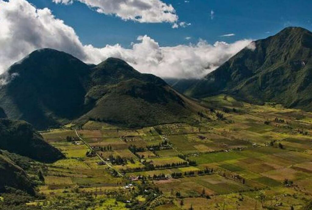
Nestled near the vibrant city of Quito, Pululahua emerges as an oasis of tranquility. As the sun sets, moisture-laden clouds drift in from the Pacific coast, enveloping the area in a serene ambiance. Uniquely designated as a “Geobotanical Reserve,” Pululahua stands as the sole protected region in the country with this prestigious classification. This speaks volumes about its significance, rooted in distinctive geology and a captivating volcanological history. Beyond the lush flora blanketing its slopes, the reserve safeguards a truly extraordinary phenomenon: a volcanic caldera teeming with life. It’s undoubtedly a place where the Earth’s energy resonates in every rock and every passing cloud.
The Geological Tapestry of Pululahua
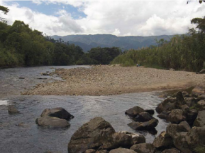
The grand caldera unfolds as a testament to the collapse of rocks and earth, remnants of successive eruptions from the Pululahua volcano. Subsequent volcanic domes, namely Pondoña, El Chivo, and Pan de Azúcar hills, emerged from later eruptions, each adorned with small craters at their summits. The last eruption of Pululahua, estimated to have occurred 2,300 years ago, attracted ancient settlers drawn by fertile soils and abundant humidity. Several towns, including Nieblí, Los Reales, and Pululahua, now inhabit the caldera’s interior. During colonial times, the lands forming the reserve belonged to the Dominican order, later passing to the State in 1905 amid the liberal revolution. Post the agrarian reform, the land became the rightful possession of former hacienda workers.
A Journey Through Time: Agricultural Roots
Pululahua’s historical prominence stems from its agricultural prowess and the extraction of lime used in constructing Quito’s houses. Notably, the tireless efforts of scientist Misael Acosta Solís (1910 – 1994) elevated Pululahua to national acclaim, eventually leading to the establishment of Pondoña National Park, the first protected area in continental Ecuador. In 1978, it officially assumed the title of Pululahua Geobotanical Reserve.
Biodiversity Flourishes Amidst Foggy Enchantment
The copious fog penetrating the crater creates diverse microclimates, nurturing exuberant vegetation on the slopes. Bromeliads and orchids, with approximately 100 recorded species, dominate the landscape, including the ubiquitous small purple maigua. Zagalitas, zapatitos, colcas, sigses, pumamaquis, wild taxa, and allpa chocho add to the rich tapestry. The reserve hosts an impressive 180 bird species, featuring the majestic black-chested eagle or guarro, the elusive quilico, melodious blackbirds, and the iconic huirac.
Discovering Pululahua’s Hidden Gems
Community of Pululahua
Situated in the caldera’s agricultural heart, this community invites visitors to partake in diverse recreational activities.
Viewpoint Windows
For the closest and most accessible glimpse of the reserve’s awe-inspiring panorama, head to the Viewpoint Windows.
Lime Kilns
The ancient lime kilns in El Bucal stand as historical relics, offering a fascinating glimpse into Pululahua’s industrial past.
In essence, Pululahua Geobotanical Reserve stands as a living testament to the intricate dance between nature and history. Its allure lies not only in the geological marvels but also in the stories etched in its soil, inviting adventurers to uncover the secrets held within this captivating landscape.