Unveiling Machalilla’s Historical Significance
Machalilla National Park stands as a pioneer among Ecuador’s protected areas, gaining official recognition in 1979. This early acknowledgment underscores the park’s vital role in safeguarding diverse ecosystems, including dry and semi-dry forests and the marine-coastal zones of southern Manabí. The park’s nomenclature pays homage to the Machalilla culture, a paramount pre-Hispanic society in the coastal region, thriving in the area from 1800 BC to 1000 BC.
Archaeological Marvels and Cultural Tapestry
Within the park and its vicinity lie archaeological sites spanning various eras, from the Valdivia culture over 5,000 years ago to the Manteño-Huancavilca culture 500 years ago. These sites unveil a tapestry of ancient civilisations that called Manabí home. Notably, the park hosts evidence of the Machalilla region’s first inhabitants, providing a glimpse into their lives and cultures.

Sistema Nacional de Áreas Protegidas (2011)
Geographical Diversity: A Landscape Unmatched
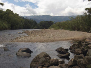
Machalilla’s land area encompasses the territories of five watersheds: Cantagallo, Jipijapa, Salaite, Buena Vista, and Ayampe rivers. Ayampe and Buena Vista, representing nearly two-thirds of the protected area, dominate with their size. Populated centres like Puerto Cayo, Machalilla, Puerto López, and Salango add a human dimension to the park’s diverse topography.
Coastal Charm and Varied Topography
In contrast to other coastal areas, Machalilla’s coastal strip boasts irregular topography, featuring high cliffs, rocky beaches, sandy expanses, and valleys connecting directly to the Pacific. This dynamic landscape provides a habitat for diverse marine organisms in intertidal pools, showcasing the region’s ecological richness.
Maritime Marvels: Islands and Ancient Trade Routes
The marine area encompasses tranquil bays and coves, with a continental shelf giving rise to islands like Salango, Horno de Pan, Sucre, Pedernales, and the renowned Isla de la Plata. Archaeological findings spanning 7 to 8 thousand years suggest a rich pre-Hispanic history. The Manteño-Huancavilca culture (1500 BC – 500 AD) played a pivotal role in trade and navigation.
Cultural Legacy and Maritime Prowess
The Manteño-Huancavilca culture left an indelible mark on the region, controlling pre-Hispanic trade between the continent’s north and south. Their seafaring expertise, evidenced by large rafts and navigational prowess, positions them as key merchants of their era. Stone thrones found in civic-ceremonial centres serve as enduring symbols of their power and significance.
Community Harmony and Agricultural Pursuits
Presently, the park houses 12 communities primarily engaged in agriculture. Protecting a vast stretch from Chonchón-Colonche coastal range to Isla de la Plata’s marine environs, Machalilla serves as a haven for biodiversity.
Flora and Fauna Extravaganza
The park boasts diverse landscapes, featuring garúa forests with amarillo, palo de ajo, fernán sánchez, tillo blanco, tagua, and paja toquilla trees, along with numerous orchids and bromeliads. Montane guans, toucans, tanagers, woodpeckers, and woodcreepers grace the skies, while the iconic greater green macaw adds vibrant hues to the region.
Terrestrial Treasures: Dry and Semi-Dry Forests
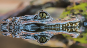
In the lower reaches of the mountain range, dry and semi-dry forests thrive, showcasing adaptations to water scarcity with cacti, palosantos, muyuyos, and guayacanes. Motmots, parakeets, ovenbirds, and laughing falcons inhabit these areas, accompanied by mammals like deer, armadillos, anteaters, and fruit bats.
Coastal Flora and Marine Conservation
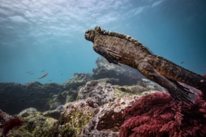
Shrubs with salt bush and realito or rompeolla line the beaches, hosting the nesting grounds for Ecuador’s four sea turtle species: hawksbill, green, olive ridley, and leatherback. Beneath the waves, rocky reefs and coral communities flourish, especially around Isla de la Plata, sustaining diverse marine life.
Underwater Wonders: A Marine Sanctuary
The marine area is a treasure trove of biodiversity, with 143 fish species. These include sierra, grouper, white huayaipe, feather duster, various sharks (including the majestic whale shark), and captivating butterflyfish and parrotfish.
Manta Rays and International Recognition
A highlight is the giant manta ray, a shark-relative reaching eight metres. The park’s richness led to its designation as a “wetland of international importance” under the Ramsar International Convention.
Isla de la Plata: A Seabird Haven
Among the park’s gems, Isla de la Plata stands out, offering sanctuary and nesting sites for diverse seabirds. Masked boobies, blue-footed boobies, frigates, tropical birds, small petrels, and terns grace the skies, creating a captivating spectacle near the beaches and rocks.