Cotopaxi National Park is a true wonder of the world, boasting the Cotopaxi volcano, a snow-capped cone that stands at an impressive 5,897 metres above sea level. It’s a true natural wonder, recognised globally as one of Ecuador’s top natural landmarks alongside the Galapagos Islands. Mountaineers from across the globe have climbed its summit, with countless others hold aspirations of one day achieving the same. Situated in the inter-Andean alley and in close proximity to cities such as Quito and Latacunga, the Cotopaxi National Park is one of Ecuador’s most visited attractions. It’s also an excellent destination for Ecuadorian locals to touch snow for the first time.

Sistema Nacional de Áreas Protegidas (2011)
Unveiling Ecuador’s Natural Marvel: Cotopaxi Volcano
Cotopaxi is one of the tallest active volcanoes in the world and is part of the “Avenue of the Volcanoes,” a group of volcanoes in the central and northern Sierra of Ecuador that German naturalist Alexander von Humboldt named in 1802. The park covers a vast area, including two smaller volcanoes, Morurco (4,880 m) and Rumiñahui (4,721 m), which are adjacent to Cotopaxi.
Cotopaxi is the second highest mountain in Ecuador, and the highest active volcano in the country, although its activity is never as strong as that of its neighbours, Sangay and Tungurahua. Fumaroles are sometimes visible on the Cotopaxi’s eastern flanks and along the Pita River, which flows north. These are a result of the volcano’s last significant eruption in 1877, which caused large rocks and volcanic materials to scatter along the river’s path.
Discovering Cotopaxi’s Geological Characteristics: A Stratovolcano
Cotopaxi is a stratovolcano, a type of cone-shaped mountain formed from accumulation of rocks, sand and ashes from successive eruptions. The paramo’s black soil has formed from this material. It amazes visitors with its perfectly conical shape, glacier, and Yanasacha, a huge wall of black rock visible from the north. The crater measures 800 metres in diameter and 334 metres in depth.

Cotopaxi’s Cultural Significance
Cotopaxi is a sacred mountain for many indigenous ethnic groups, admired by both locals and foreigners. Its name’s origin is of Kichwa and Aymara influence, with “coto” meaning neck or throat in Kichwa and “paxi” referring to the moon in Aymara. Thus, the interpretation of Cotopaxi’s name is “neck of the moon.”
Cotopaxi’s Explosive History
The most violent eruptions recorded occurred in the 16th and 17th centuries, while the most recent significant eruption was in 1877. Mud and rock movements made their way to the Pacific Ocean and the Amazon, and as a result caused significant damage to Latacunga and the Los Chillos valley located towards the southeast of Quito.
Exploring Cotopaxi’s Hydrographic System
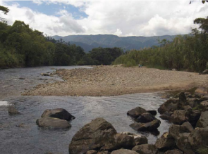
The primary hydrographic system within the province, sharing its name with the volcano, is formed by the Cutuchi River, originating from Cotopaxi and created by the convergence of the Manzana huayco and Rumiñahui rivers. The Cutuchi River eventually transforms into the Patate River, flowing towards the Amazon.
Life Forms in the Paramo Ecosystem
The park’s predominant ecosystem is the paramo, an area characterised by its unique flora and fauna. Its main vegetation consists of grassland and small shrubs. The paramo ecosystem is mostly protected, making it fascinating to observe vegetation’s adaptability in such a harsh climate. The extreme paramo conditions cause plants to develop unique adaptations, with the most common one being the pajonal. Its long, thin leaves retain more water in comparison to the broad leaves of other common plants. In addition, they protect fragile young leaves and flowers in the centre of the tuft. Moreover, chuquiragua shrubs have small, tough leaves that can endure the limited water supply.
In the paramo ecosystem, many plants grow closely together forming thick cushions that create a microclimate, which shelters delicate young parts. Rosettes without stems, like chicory and one type of valerian, are situated near the ground. Their leaves are tightly packed together to retain moisture and create warmth. Meanwhile, trees such as yaguales and kishwares have small, shiny, hairy and rigid leaves to shield them from the cold and radiation. The trees’ stems also retain heat and water. There are also many herbs, such as gentians, ferns, and deer horns, that take advantage of the proximity to other plants to survive in the paramo. Cotopaxi also has a plant named after it, Cotopaxia asplundii, from the celery family, which grows near the Limpiopungo lagoon.
Wildlife Abound: Discovering Cotopaxi’s Animal Kingdom
The park is home to several animal species, including marsupial mice, field mice, and Andean wolves, although they can be difficult to spot. Visitors are more likely to see rabbits, skunks, Andean weasels known as chucuris, hawks, eagles, Andean gulls, condors, and bandurrias soaring in the sky. Andean coots and Andean ducks can be seen swimming in the Limpiopungo lagoon. Marsupial frogs, cutines, lizards and guagsas complete the range of diversity.

Rumiñahui and Limpiopungo Lagoon
Rumiñahui is a collapsed volcano with three peaks that give it a rugged appearance. The walls surrounding the caldera collapsed, possibly because of the forceful discharge of the magma chamber, resulting in peaks that reach a height of 800 metres. The highest one is the north peak at 4,721 metres above sea level, but the central one, at 4,630 metres, is the most climbed. The volcano takes its name from the last indigenous warrior who heroically resisted the Spanish invasion, and whose name means “stone face.”

Limpiopungo lagoon, located at an altitude of 3,800 metres, covers approximately 200 hectares. Unlike other lagoons, this one doesn’t have a distinct boundary, and the surrounding landscape gradually transforms into marshland. Many totora plants grow here, among which ducks nest, and Andean seagulls and other birds fly around the lagoon.
Enchanted Valley and Pita River Canyon
The Enchanted Valley, located on the eastern side of the park, offers visitors the chance to see the traces of Cotopaxi’s most recent violent eruption, including lahars and stones that were forcefully ejected from the volcano.
The Pita River flows through a gorge which slowly leads into forests and farmland beyond the park, where it forms impressive waterfalls. This river is one of the sources of drinking water consumed in Quito.
Activities in Cotopaxi National Park
Visitors to Cotopaxi National Park are spoiled for choice when it comes to activities that embrace the park’s natural splendour. Adventurous souls can embark on thrilling hikes, visiting the Cotopaxi base camp and glacier and conquering the trails that wind through the mesmerising paramo ecosystem, while mountaineers can challenge themselves with a climb to the summit of the iconic Cotopaxi volcano. Wildlife enthusiasts can indulge in birdwatching, spotting majestic condors and other avian wonders, or simply immerse themselves in the tranquil beauty of Limpiopungo lagoon. From mountain biking down the volcano to horse riding, Cotopaxi National Park offers an array of experiences, inviting visitors to forge unforgettable memories in this captivating corner of Ecuador.