Cayambe-Coca National Park, located in Ecuador, is a natural treasure that captivates visitors with its awe-inspiring landscapes and abundant water sources. With its snow-capped Cayambe volcano and the origins of the Coca River, the park showcases nature’s grandeur. However, it is the park’s remarkable water features that truly set it apart. From mist-laden environments to lush vegetation and cascading waterfalls, water permeates every aspect of this pristine sanctuary.

Sistema Nacional de Áreas Protegidas (2011)
Exploring the Water Wonderland
A Paradise of Aquatic Wonders
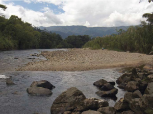
In the Cayambe-Coca National Park, water is omnipresent, creating a paradise of aquatic wonders. The constant mist and rainfall blanket the surroundings, while the vegetation and leaf litter on the ground glisten with moisture. As you venture into the highlands, you’ll encounter wetlands, lagoons, and rivers that give birth to breathtaking waterfalls and cascades. Notably, this region boasts renowned thermal and mineral springs like Papallacta and Oyacachi, offering visitors a rejuvenating experience. The park serves as the origin for significant rivers such as Dué, Chingual, Cofanes, and Cuyabeno, which converge with the Coca River and eventually join the mighty Napo River.
Western Foothills: Cradling Life-Flowing Springs
Towards the western foothills of the park lies a haven of life-flowing springs that nourish the Mira and Esmeraldas rivers, flowing gracefully into the Pacific Ocean. Alongside the prominent Cayambe volcano, the region boasts other notable elevations, including Saraúrco (4,725 m altitude) and Cerro Puntas (4,425 m altitude). Cerro Puntas stands out with its 48 imposing rocky teeth, lending it a distinctive and captivating appearance. Descending into the lower zone of the park, one encounters the majestic Reventador volcano.
Glacial Lagoons: Jewels of Pristine Beauty
The park boasts a stunning complex of 80 glacial lagoons, fed by the melting snow of Cayambe. This remarkable collection has been designated an important wetland and holds global significance as a Ramsar site. Accessible lagoons include Papallacta and the San Marcos lagoons. Both are connected by secondary roads branching off from the Interoceanic Highway and the Ayora to Olmedo road, respectively. These lagoons offer a serene escape into nature’s tranquil embrace.

A Journey Through Diverse Landscapes and Cultures
Gateway to Ecuador’s Rich Cultural Heritage
Cayambe-Coca National Park offers visitors a unique opportunity to traverse diverse landscapes and encounter a rich tapestry of cultures. In a matter of hours, one can journey from the lofty peaks of the eastern mountain range to the sprawling Amazonian plains, immersing themselves in the vibrant tapestry of mestizo and indigenous communities of the Sierra and Amazonia. Along the Andean valleys, the traditional cities of Cayambe and the parish of Olmedo showcase their historical charm. These lands were once inhabited by the Kayambis and Karankis, and ancient festivals like Inti Raymi, celebrating the summer solstice, still endure today. Towards the park’s eastern periphery, noteworthy foothill cities like Baeza, El Chaco, and Lumbaqui emerge, representing significant historical routes taken by Spanish explorers in their quest for El Dorado. Baeza, renowned for its enchanting wooden houses adorned with vibrant flowers, has earned the distinction of being a National Cultural Heritage site.
Within the park’s boundaries lies the town of Oyacachi, home to the Kichwa community famous for their alder wood crafts. Oyacachi also attracts hundreds of visitors each year to its soothing thermal pools. This indigenous community has a remarkable history, as it was here that an apparition of the Virgin Mary was initially witnessed in a cave, which was subsequently carved in wood. This holy representation, known as the Virgin of El Quinche, was eventually moved from Oyacachi and still holds great significance.
A Biodiverse Haven
Ecosystems Teeming with Life
Cayambe-Coca National Park boasts an impressive array of plant and animal species, thriving across its diverse ecosystems. With 100 species of endemic plants, 200 mammal species, 900 bird species, 140 reptile species, and 116 amphibian species, the park stands as a biodiversity hotspot.
Enchanting Paramo Plains
Venturing into the expansive paramo plains, one can witness the enchanting dance of cervicabras and rabbits amidst the grass, while the curiquingue or paramo partridge gracefully roams the landscape. Weasels, known as chucuris, and various species of paramo mice, including an aquatic variety, elegantly navigate the vegetation. Majestic creatures such as the white-tailed deer, the spectacled bear, and the mountain tapir roam these lands. The skies above showcase the elegant flight of hawks, curiquingues, and Andean condors, while ducks and seagulls gracefully glide across the shimmering lagoons. As night falls, the paramo wolves and skunks make their presence known. Dense forests, interwoven with paper trees or yagual, create an enchanting maze. Patches of plants like taruga, chicory, chuquiragua, romerillo, licopodio, and achupalla add to the tapestry of botanical wonders.
Splendour of the Andean Forest
Descending further, visitors encounter the resplendent Andean forest in all its splendor. Towering trees such as pumamaquis, colcas, suros, olives, cedars, guabos, and alisos thrive, adorned with delicate mosses and ferns. Large tree ferns create an ethereal ambiance. Within these forests, one can encounter the Andean toucan, the mountain pava, and the quetzal, adding vibrant splashes of colour to the surroundings. Near waterfalls and on rocky slopes, colourful birds with red crests, known as rock cocks, nest and perform their captivating reproductive dance accompanied by their melodious squawks during the early morning and twilight hours. Rivers flowing through rocky terrains are home to torrent ducks and white-capped dippers.
Abundant Wildlife in Lower Regions
Reaching the lower regions of the park, a tapestry of wildlife unfolds. Macaws, parrots, toucans, king vultures, guantas, guatusas, tapirs, cuchuchos, heads of mate, cusumbos, and a variety of monkeys such as squirrel monkeys, night monkeys, spider monkeys, and howler monkeys grace the landscape. The heliconias or platanillos and anthuriums showcase their conspicuous blooms, while palms such as chambira, chonta, and palmito tower above. Here, the trees grow taller, with larger leaves, and the temperature rises, indicating the transition into the Amazon region.
Nature’s Marvels
Volcano Cayambe: Where Equatorial Majesty Reigns
Standing at a majestic height of 5,790 metres, Volcano Cayambe holds the distinction of being the highest point along the equator line in Ecuador. This iconic mountain allures mountaineers with its rugged terrain, ice lagoons, and the graceful presence of condors soaring through the skies. Ascending its slopes promises a truly captivating experience.

San Rafael Waterfall: A Glimpse of Nature’s Power
Located within the park, the San Rafael Waterfall mesmerises visitors with its raw beauty and immense power. The Alto Coca River plunges 160 metres, creating Ecuador’s largest waterfall. This magical display of nature’s force is a sight to behold and leaves spectators in awe of its grandeur.
Soothing Thermal Waters
Renowned for their healing properties, the thermal waters of Cayambe-Coca National Park provide a soothing retreat for visitors. Among the well-known thermal springs are those found in the Oyacachi community and the Papallacta area. Thanks to the volcanic activity of Antisana and Reventador, these thermal waters reach temperatures of up to 60°C. Apart from their relaxing qualities, these mineral-rich waters offer therapeutic benefits, making them a popular destination for wellness seekers.
Conclusion
Cayambe-Coca National Park stands as a remarkable testament to Ecuador’s natural and cultural heritage. From the captivating landscapes of snow-capped peaks, expansive paramo plains, and enchanting forests to the rich cultural tapestry woven by indigenous communities, the park offers an unforgettable experience. Whether exploring its diverse ecosystems, embarking on mountain adventures, or seeking tranquillity in thermal waters, visitors are immersed in the magnificence of this protected sanctuary.